Before I go on, I want to thank Jan for sending me the information on the Cow Moose signs. Here is the link to that information:
One of the reasons we came here is that I wanted to see the Ksan Village and Museum and to learn about the Native Peoples of this region. The campground is within walking distance to the village and when I got there - there was a sign about water problems and they were closed. WHAT A BUMMER! But, I could still walk around so that is what I did.
There are buildings and totem poles:
Just another tidbit - We are camping in the village of Gitanmaax.
"The Gitanmaax Band is a band government of the Gitxsan people, based near the meeting of the Skeena and Bulkley Rivers, adjacent to the village of Hazelton and 5 km west of New Hazelton, in northwestern British Columbia, Canada. Our vision is to restore and maintain healthy traditional community values; while actively participating in the new economy."
Sadly I cannot give you any history on this - Bummer.
From there I took one of the walking paths back to the campground:
Since I did not spend much time at the village, we decided to head out on a road trip.
Our first stop was Hagwilget Canyon and the suspension bridge.
There are two lookouts. Views from the north side - the Stekwayden Mountains:
Then we traveled to the south side of the bridge:
https://en.wikipedia.org/wiki/Hagwilget_Canyon_Bridge
https://www.historicplaces.ca/en/rep-reg/place-lieu.aspx?id=14605
The bridge is open to pedestrians and I thought about it until I looked down when we were driving over it. The views are incredible but my tummy and legs did the once over so NO! Not going to happen - LOL!
Our next stop was the visitor center where we picked up some information on the Native Sites in the area. And sadly, their artifact museum was closed... (Sheesh!)
We also found out the directions to the Kispiox Totem Poles where some of those poles are over 150 years old.
Sites around the visitor center:
https://www.cathedralgrove.eu/text/06-Totem-Poles-2.htm
The characteristic figures on totem poles are symbols comparable to family crests. They illustrate historical events that occurred in a House's past. If the historical event involved several houses, those Houses may share the crest." "The pole's owners display their crests on the pole to establish and make public their claims to vested rights and privileges. They varied with each family; they were exclusive property and were guarded. Each carved illustration on the poles serve a multiple purpose: besides commemorating the dead and showing ownership, they familiarize youths with their histories — keeping part of our heritage alive" Kispiox Totem Poles. | |
Our last stop was Old Hazelton to see the replica of the S.S Sternwheel.
See that yellow tape - yes, they were working on it. Darn, not having good luck today. But hey, the scenery in incredible!!!!!
One last thing to leave you with...
Amazing!
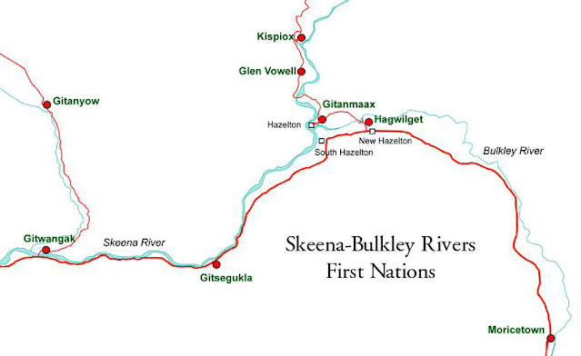
Here is a map of the First Nations in this area. We are staying in Gitanmaxx, the bridge is at Hagwilget, and the totem poles at in Kispiox.
In 2009, we were at Gitanyow: https://thehitzels.blogspot.com/2009/09/september-5-2009-cassiar-and-totem.html
We are blessed!
So for a day that started with a little disappointment because of a closure - it turned out to be an incredible remainder of the day.
-----
Tomorrow we are heading north to the Cassier. We are bypassing Hyder and Stewart because it is going to rain and will be raining there for the next few days.
I am told that we will not have cell service nor internet for the length of the Cassier which is about 400 miles. Updates and any FB will not be happening.
So see you when we get to the Yukon.
OH MY YES!


.JPG)
.JPG)
.JPG)
.JPG)
.JPG)
.JPG)
.JPG)
.JPG)
.JPG)
.JPG)
.JPG)
.JPG)
.JPG)
.JPG)
.JPG)
.JPG)
.JPG)
.JPG)
.JPG)
.JPG)
.JPG)
.JPG)
.JPG)
.JPG)
.JPG)
.JPG)
.JPG)
.JPG)
.JPG)
.JPG)
.JPG)
.JPG)
.JPG)
.JPG)
.JPG)
.JPG)
.JPG)
.JPG)
.JPG)
.JPG)
.JPG)
.JPG)
.JPG)
.JPG)
.JPG)
.JPG)
.JPG)
.JPG)
.JPG)
.JPG)
.JPG)
.JPG)
.JPG)


